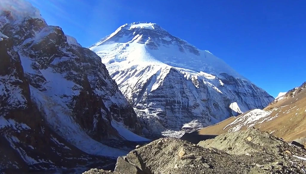
Trip Overview
The Dhaulagiri Circuit Trek of 20 days is one of the longest and toughest high-altitude treks in Nepal. Circumnavigating the 7th-highest mountain in the world, Mt. Dhaulagiri (8,167 meters/26,795 ft), what makes the Dhaulagiri Circuit Trekking Trail special is its unspoiled natural and cultural beauty as one of the least-trodden Himalayan treks in Nepal. Right from the start of the Dhaulagiri Circuit Trekking itinerary, you can enjoy superb, diverse scenery.
Get ready to embrace a wide range of Nepalese people and terrains, from subtropical jungle to a geographic extension into the high, dry Tibetan Plateau. The mix of lush vegetation, massive mountain peaks, and numerous tiny yet beautiful villages makes every step into the Dhaulagiri Circuit Trek route worthwhile. Starting from Beni in Myagdi district and towards the east, which is home to a mix of Magar and Gurung people, we are here to ensure you hassle free experience.
While the Dhaulagiri Circuit Trek itinerary is already the best due to the dedicated spare days for ample acclimatization, so you do not experience altitude sickness, we are also happy to offer a customization option. We are flexible and do our best to meet your preferences and requirements. This means the exact Dhaulagiri Circuit Trek Cost may vary based on the changes made, but it is, however, reasonable overall.
Bookings are now open for 2026 and 2027. Reserve your seat early or with a group of more than 10 members and get to enjoy special discounts on this Dhaulagiri Circuit Trekking Cost, including for the years 2026 and 2027. Based in the heart of the Kathmandu Valley, Thamel, our more than two decades of experience make us a reliable travel companion in Nepal. Your safety is our top priority. Contact us now to save your spot!
Things to anticipate on the trekking route to complete the Dhaulagiri Circuit Hike
The Dhaulagiri trail follows the Myagdi Khola, a river that drains the southern side of the Dhaulagiri massif. Passing through the settlements of Darbang and Muri, the country is still quite heavily populated with scattered villages and farming land. Beyond Muri, the river swings north, and the landscape becomes much more rugged and sparsely populated. The tree line is reached just below the site of the Italian base camp.
Like this, the Dhaulagiri Circuit Trekking offers you a true Himalayan wilderness behind Mt. Dhaulagiri into the trans-Himalayan region, a rain shadow area that has yet to receive a number of adventurers like other popular treks in Nepal do, such as the Everest Base Camp Trek, the Annapurna Base Camp Trek, and the Langtang Valley Trek. Crossing several passes further can add to the challenges and, hence, is recommended for seasoned trekkers rather than first-timers.
Where does the Dhaulagiri Circuit Trek take you?
The Dhaulagiri Circuit Trekking route falls within the Annapurna Region, which is further famous for high altitude treks such as the Annapurna Circuit Trek, Khopra Danda Trek, Mardi Himal Trek, Ghorepani Poon Hill Trek, and, of course, the Annapurna Sanctuary Trek. But the Dhaulagiri Circuit Trek Trail has more remote and dramatic parts. Fewer trekkers even during the peak trekking seasons of spring and autumn.
Trekkers follow the Myagdi Khola Valley and are to make it to the Dhaualgiri Base Camp just below the towering peaks at the center of glaciers and stunning alpine landscapes, in stark contrast to what you experienced in the lower region and villages. Deep into the high Himalayas guarded by Mount Dhaulagiri, before you descend into the beautiful Kali Gandaki Gorge, also famed as the deepest gorge in the world.
Why is it a luxury to get a teahouse on the circuit trekking route to Dhaulagiri?
There are hardly any larger villages on the Dhaulagiri Circuit hiking route, let alone the teahouses. Beni, Darbang, Dharapani, Muri, Bogohara, Dobhan Kharka, Salla Ghari, Yak Kharkha, and Marpha are here, but most of these features with sparse human settlements lie quite far from each other. That is why a teahouse itself is a luxury in itself, as is the fulfillment of daily nutrients and safer drinking water, which is lukewarm boiled water.
But it is also what provides the right ambience for a more intimate experience, not spoiled by the modern era's rapid urbanization, chaos, and pollution. Throughout the Himalayan trip to complete the 20-day Dhaulagiri Circuit Trekking, you get to see the real lifestyle of two indigenous communities of Nepal native to the Himalayan region: the Magar and the Gurung. Content in their own world of hills and Himalayas, they are simple and welcoming.
Is this trip suitable for wildlife sightseeing and photography?
Most of the trekking to circumnavigate Mt. Dhaulagiri, as the name suggests, goes through the Annapurna Conservation Area for being a home to a wide range of flora and fauna, including a diverse landscape from lush subtropical to alpine meadows and almost desert-like landscapes as you go higher in sharp contrast to the snow-blanketed mountain ranges perching above the sky; there’s a lot to see and capture in your lenses.
Therefore, yes, the Dhaulagiri Circuit Himalayan Trip does cater to individuals also keen on wildlife and photography. On a lucky day, you may even come across rare and elusive species of snow leopard, Himalayan musk deer, blue sheep, Himalayan tahr, Himalayan black bear, and red panda. Listen to your guide, and if it is your core area of interest, communicate so they can introduce you to the most scenic spots and places with higher chances of wildlife sightseeing.
Do you cross high mountain passes during the trek to complete the Dhaulagiri Circuit?
Yes, you do cross multiple high mountain passes to complete the Dhaulagiri Circuit Trekking of 20 days. These passes, along with being physically demanding and often regarded as the real challenging phase, are also the ones that reward you immensely if you have trained yourself for it. French Pass and Dhampus Pass are both located 5,000 m above sea level, so to make it through here safely, proper acclimation is a must.
Trekkers begin earlier than usual, so you do not have to face the strong afternoon wind, and also so that you get to relish the magical sunrise over the glazing mountains and then slowly descend to the green valleys and villages. However, the high mountain pass trails of the Dhaulagiri Circuit Trek also tend to be colder, often snowy, and have sharp ascents at first and later on full of descents. Get ready to push your limits.
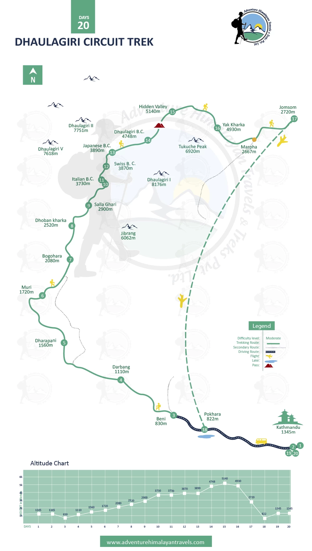
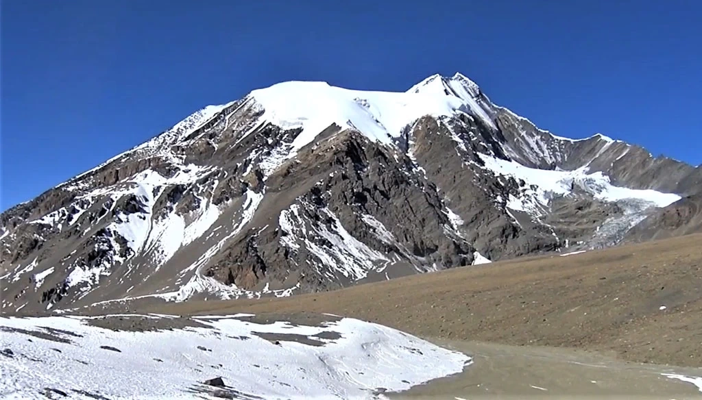
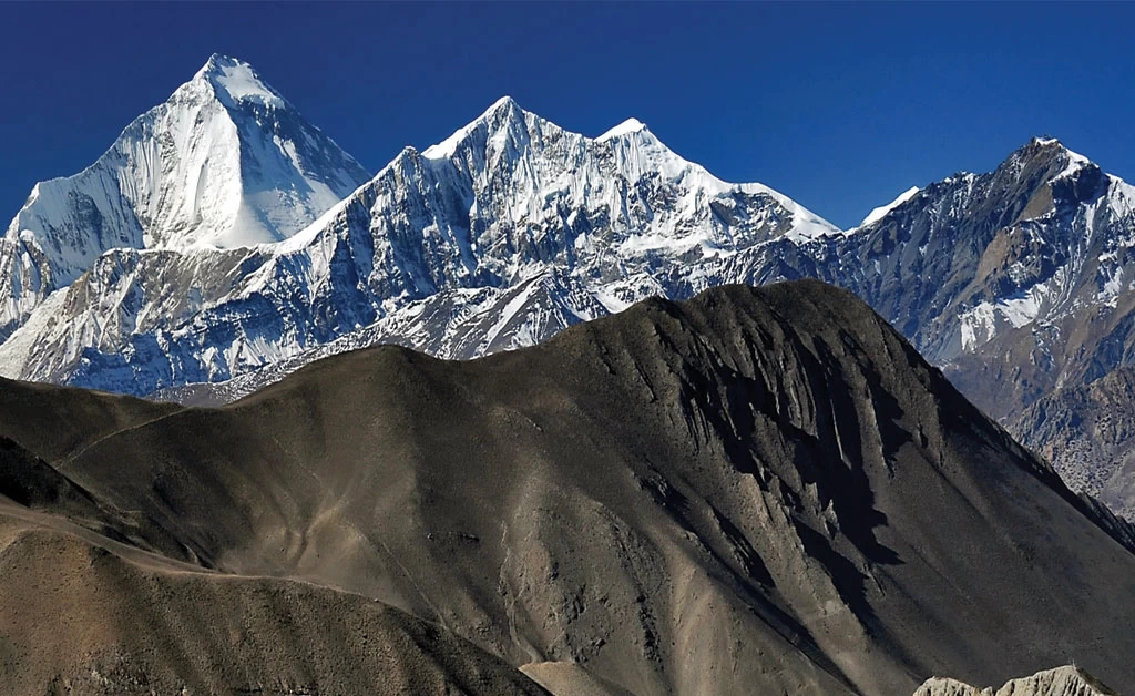
Which mountains are visible while on the Dhaulagiri Circuit Trek Trail?
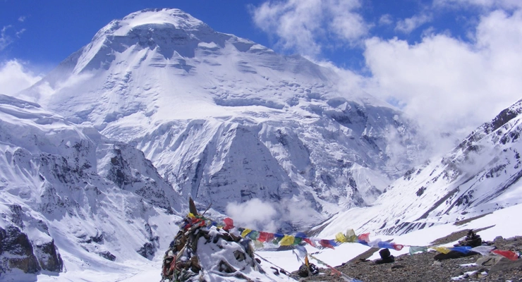
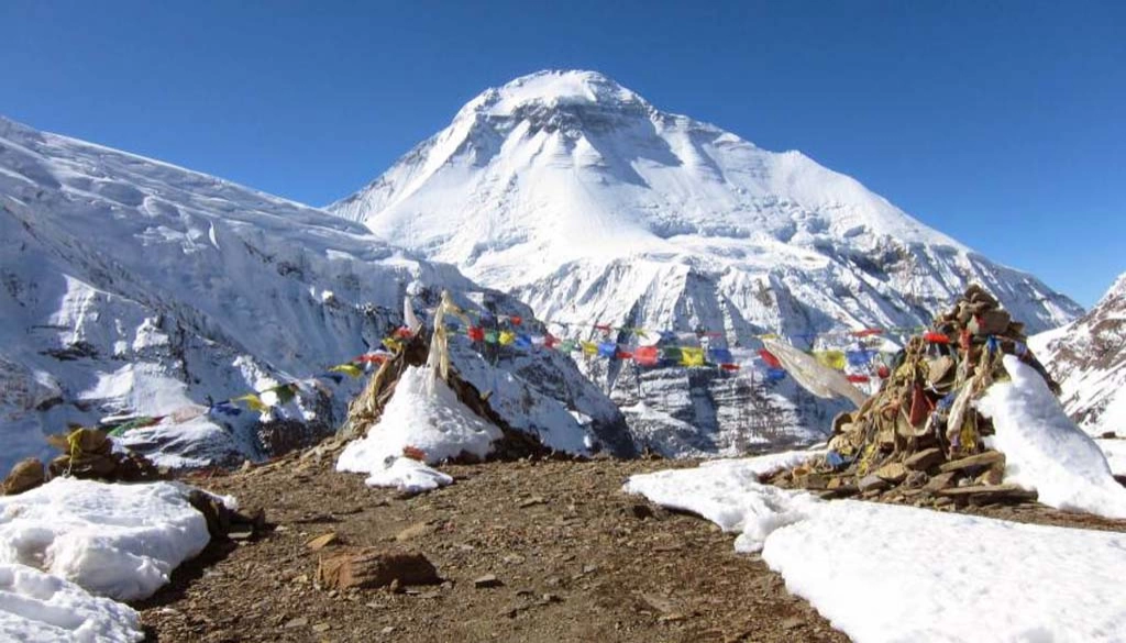
You can see several mountain ranges on the Dhaulagiri Circuit Trekking route. Along with Nilgiri and Tukuche Peak, views of multiple 8,000 m peaks ensure you a visual retreat. Annapurna, Manaslu, and, of course, Mount Dhaulagiri and its ranges II, III, and IV. These peaks look further refined from high-altitude landmarks such as Italian Base Camp, Swiss Base Camp, Japanese Base Camp, Dhaulagiri Base Camp, French, and Dhampus Pass.
No need to worry; our 20 days Dhaulagiri Circuit Trek itinerary promises that you get all the golden chances to make the best out of all of these. Breathe in and take in all the unforgettable, one-of-a-kind scenery that only a few get to see; the sights combined with the warm hospitality of the locals do make up for all the hardships. The unpredictable Himalayan weather and challenging geographical conditions give you a taste of mountaineering.
Why is the Dhaulagiri Circuit Trekking Itinerary of 20 days the best? The cost for 2026 and 2027
It is because the 20 days of the Dhaulagiri Circuit Trek itinerary allow a well-paced, hassle-free experience with at least one buffer day at Italian Base Camp; it is taken as the best route, including for the years 2026 and 2027. Or you may choose our customization option. We are flexible and do our best to craft a personalized journey for you that matches your fitness level, preferences, and requirements. Let us plan your perfect Himalayan gateway.
Our Dhaulagiri Circuit Trekking Cost takes care of all the essential expenses such as meals, lodges, transportation, permits, a guide (their salary, insurance, trekking gear, and equipment), and also camps when needed. Changes to the itinerary and services mean fluctuations in the Dhaulagiri Circuit Trek cost. It is transparent, and we are happy to match the prices if it maintains your safety and seamless experience from start to end as we do!