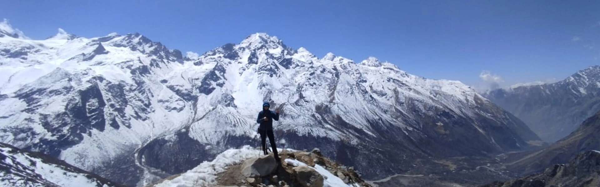
Nestled north of Kathmandu, the Langtang Valley Trekking in Nepal is one of the most easily accessible yet rewarding trekking destinations. Syarbrubesi, the common Langtang Trek starting point, is 120-122 km/75-76 miles in distance, reachable in around 7-9 hours by jeep and 8-11 hours by bus. Mid-altitude, the Langtang Region, hence, is a dream place for first-timers and families seeking memorable Himalayan holidays without extreme challenges.
Although the Langtang trekking paths are well established, and you might not have difficulties with navigation with the Langtang Valley trekking map, you will have a better understanding of distances, daily walking hours, trail variation, side trips, and logistical management. So here’s a much-needed Langtang Valley trail distance map to pack, a first step towards a successful Himalayan trip to Langtang Himalayas, the valley of glaciers of Nepal.
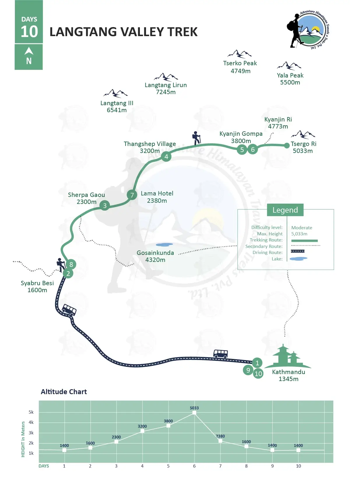
The standard Langtang Valley trekking map
Table of Contents
The Langtang Valley Trekking Path
Based on the standard Langtang Valley Trek Itinerary Map, the Langtang Valley trek path starts at Syabrubesi (1,460 m), one of the best stops on the Langtang Valley Trek route map, where you can meet trekkers from across the world preparing for various Langtang Trek trails such as Ganesh Himal Singla Pass Trek, Jugal Himal and Panch Pokhari Trek, Helambu Trek, and Tamang Heritage Trek, including the Langtang Valley Trek and side excursions.
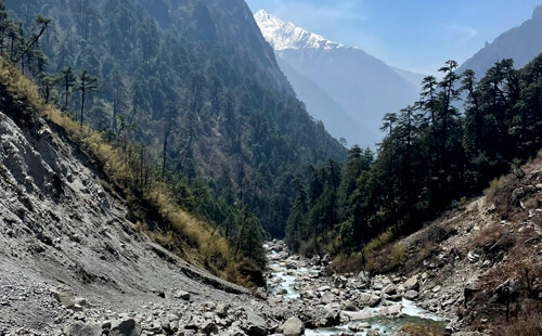
While the route thereafter diverges depending on the main destination you have chosen to hike up to, the classic Langtang Valley Trekking Trail follows the route along the Langtang Khola (river) via traditional Tamang villages with stone-roofed houses, monasteries, gompas, mani walls, prayer wheels, and prayer flags. Gradually to Kyanjin Gompa; if you prefer, you may trek up to high-altitude ridges like Kyanjin Ri, Tsergo Ri, and also Gosaikunda Lake.
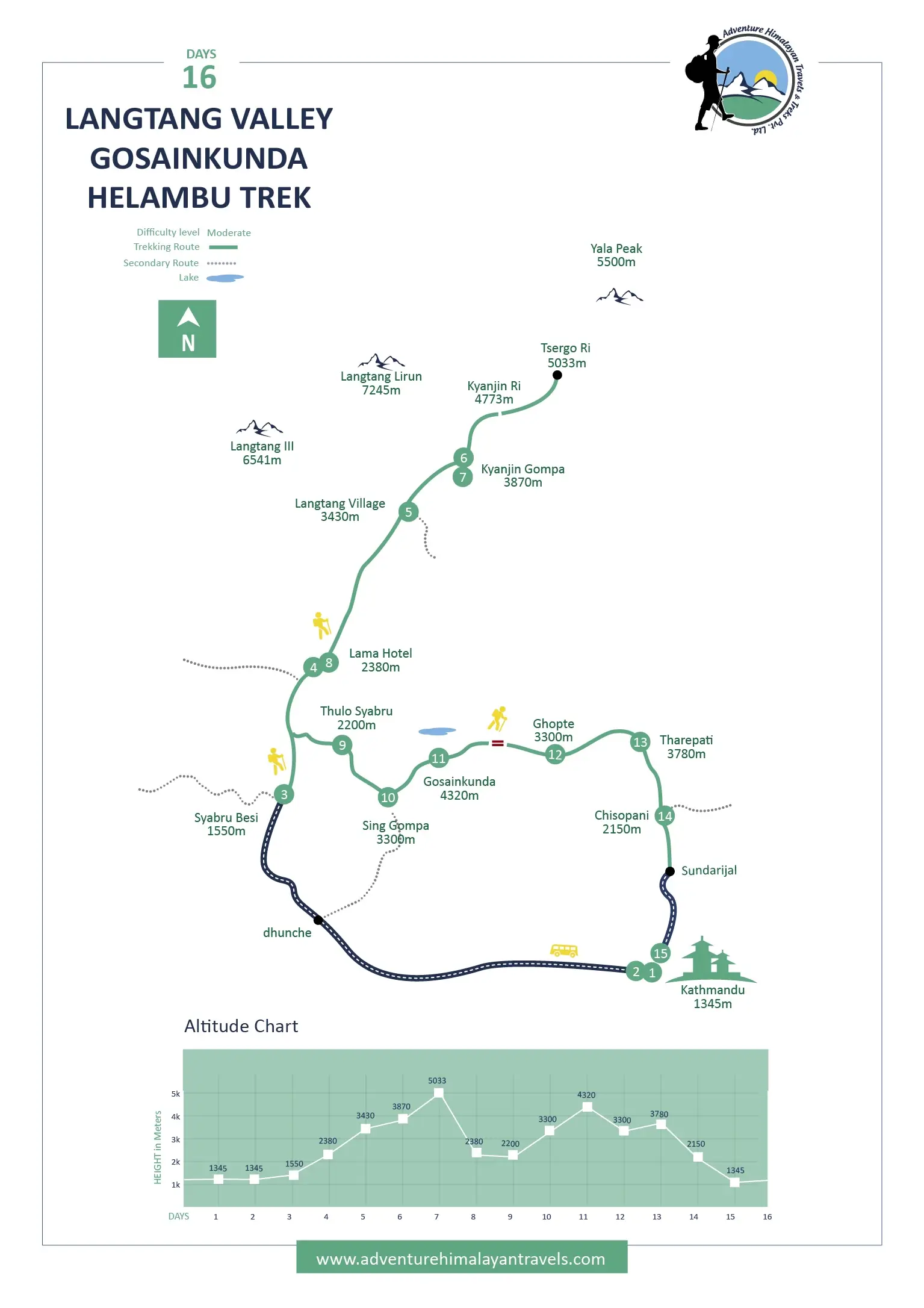
Helambu Circuit combined with Gosaikunda Lake Trekking Map in Langtang
Langtang Valley Trek Map with Walking Hours
The total Langtang Valley Trek distance covered may vary based on the itinerary and side trips you are booking. Several trekking companies in Nepal, including Adventure Himalayan Travels and Treks, offer you customizable options. If your fitness level, schedule, and budget support it, you may stay extra days at the village of your preference or extend the Himalayan trip, and the Langtang Valley Trek day can also be extended.
Otherwise, the standard Langtang Valley hiking covers approximately 65-70 km/40-43 miles from Syabrubesi to Kyanjin Gompa and back to Syabrubesi. If your pace is good and you are already used to high-altitude treks and climbs, such as the other short Ghorepani Poon Hill Trek and Mardi Himal Trek or the mid-length Everest Base Camp Trekand Annapurna Base Camp Trek, you may even complete it earlier, which in general takes 7-10 days.
Day
Route
Elevation
Walking Hours
Highlights
3
Syabrubesi to Sherpa Gaou
2,300m/7,546ft
5 to 6 hrs
Beginning of trek along the bank of the roaring Langtang Khola.
Enter the dense forested trail of the Langtang National Park.
First glimpses of snow-capped mountain giants.
Serene ambience.
4
Sherpa Gaou to Thangshep Village
3,200m/10,499ft
5 to 6 hrs
Gradual ascent to alpine meadows.
Thinning out of vegetation.
Closer insights into the authentic Himalayan culture.
Thinning of the air.
5
Thangshep Village to Kyanjin Gompa
3,800m/12,467ft
3 to 4 hrs
Open mountain views.
Yak pastures.
Cheese factories.
A major stop for potential side hikes as well.
6
Acclimatization Day
5,033m/16,513ft
4 hrs
Side trip to Tsergo Ri.
Sunrise 360-degree mountain views stretched up to Tibet.
Serenity at its peak.
7
Kyanjin Gompa to Lama Hotel
2,470m/6,716ft
6 to 8 hours
Back to the frosted areas with warmer air.
More human settlements as well.
Easy downhill retracing.
8
Lama Hotel to Syabrubesi
1,600m/5,250ft
6 to 8 hours
Final descent.
Comfortable trail with improved amenities.
Elevation gain during the trekking journey to Langtang Valley
One of the key points that makes the Langtang Trekking and the Langtang Trekking Region Trail Map easy to navigate for beginners is the gradual and steady elevation gain. From Syabrubesi to Kyanjin Gompa, the gain is nearly 2,400 m, reaching the highest sleeping point in Kyanjin Gompa at around 3,800 m above sea level. Therefore, in comparison to the Manaslu Circuit Trek and the Annapurna Circuit Trek, the risk of falling sick due to altitude here is low.
Until you add a hike to Tsergo Ri, Kyanjin Ri, or Langtang Valley Gosaikunda Lake Trek Map, trekkers do not go beyond 5,000 m above sea level. Still, it is always better not to underestimate the Himalayan trekking and climbing trails and prepare accordingly. Giving your body time to adapt to the remote, sometimes rugged, and arduous Himalayan surroundings away from modern facilities, following safety tips from the guide is essential.
The daily breakdown of the Langtang Valley Trail distance Map
As per the daily distance covered during the trekking journey to Langtang Valley, from Syabrubesi to Lama Hotel is approximately 11 km/6.84 miles, Lama Hotel to Langtang Village is around 12 km/7.45 miles, and finally, from Langtang Village to Kyanjin Gompa is comparatively shorter, about 6 km/3.72 miles. The hiking route for the Langtang Trek from Adventure Himalayan Travels & Trek follow slightly different approach.
I.e., the first day's trek is to reach Sherpa Gaon from Syabrubesi, which is around 9.8 to 12 km (6 to 7.5 miles). On the second day, you will hike to reach Thangshep Village, walking past the Langtang village, which, once devastated by an earthquake in April 2015, is now ready to welcome tourists across the globe with equally stunning rebuilt infrastructures. You cover about 10-11.4 km/6-7 miles, and Kyanjin Gompa from there is only 7 km/4.34 miles.
Key stopping points on the Langtang Trekking Map
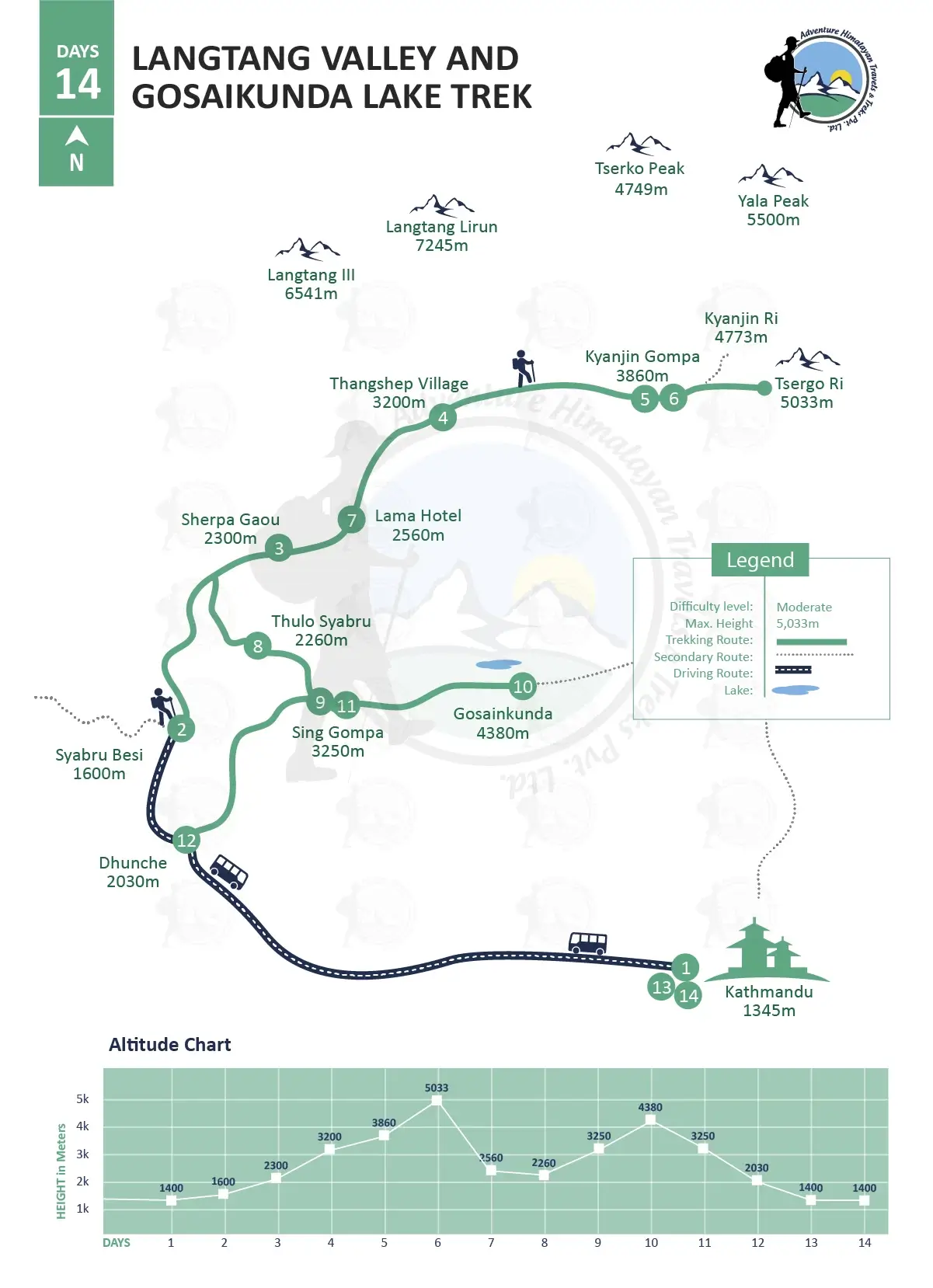
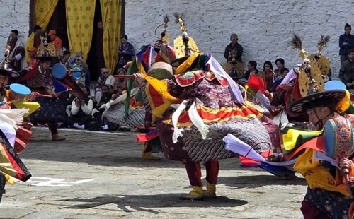
A reliable Langtang Valley hiking map is one that also marks the key stopping points so you can prepare accordingly for the journey and things to anticipate. On the Langtang Trekking Region Trail Map, LangtangVillage, Kyanjin Gompa, Gosaikunda Lake, and Sing Gompa are on the combined Langtang Valley and Gosaikunda Lake Trek and the Langtang Valley Gosaikunda Helambu Trek; they provide you with more enhanced cultural insights.
Most of these are Tamang villages, which have been able to preserve their unique cultures and traditions and dipped deeper into Tibetan Buddhism. Located at a higher altitude than the usual villages and landmarks you pass through, the crowds are minimal here, mostly only with locals, and they also serve as the best points for more expansive mountain views. Beyond mountains, the home-away-from-home hospitality is unforgettable.
Tackle the Langtang Valley Trek Trail challenges
Besides the cultural and natural highlights, the Langtang Kyanjin Gompa trek map also provides a rough idea of what awaits you on the trail. Landslide- and flood-prone areas, snowy routes, or places that experience more rain during summer, and also places with steep ascents and descents. It is so that you travel extra consciously while trekking through areas with added risks, pack appropriate gear and equipment, and also acclimatize well.
With the right Langtang Trekking Region Trail Map marking these landmarks, it gets easier for you to plan proper acclimatization before ascending to higher altitudes so you do not encounter altitude sickness, also called acute mountain sickness (AMS). When there are river crossings, or it includes making way through areas that can be affected by landslides and floods, you stay well aware and follow the professional mountain guide.
Safety and Preparation with the Langtang Valley Trekking Map
Besides the challenging sections, the well-defined Langtang Valley Trekking Trail map also mentions alternative trails, emergency helipads, health posts, and nearby teahouses as well. Although the difficulty level of the Langtang Valley Trek overall is taken as easy to moderate and may not require hardcore preparation, the better prepared you are, the easier the journey becomes from start to end. Consider cardiovascular activities.
Swimming, running, cycling, and exercise that focuses on building stamina and strength. Do prepare yourself for basic living in the remote Himalayas, where the weather can change in the blink of an eye, and having the right gear is essential so you stay warm and comfortable, and it supports mobility. Three layers of clothing, sturdy trekking boots, poles, first aid kits, power banks, and a local SIM card with data packages, and walk with confidence.
Langtang Valley and Gosaikunda Lake Trek Map
Extended Langtang Valley Gosaikunda Trek Map: Why go?
For those with more time and who want an enhanced spiritual experience, the Langtang Valley and Gosaikunda Lake Trek, or further combined with the Helambu Circuit, is just a fantastic option. The shift in scenery is dramatic, away from modern chaos to the sacred alpine lakes, often snowy and icy, and the Helmbu and Tamang heritage trails with several monasteries, gompas, and mani walls, ensuring moments for self-reflection.
You will not regret branching off at Thulo Syabru, climbing to Sing Gompa, and arriving at holy Gosaikunda Lake. In between, you will also cross the Laurebina Pass (4,610 m), an adventurous twist and a golden opportunity for thrill seekers who want a taste of mountaineering. Though nontechnical, the sense of achievement and open views in such an arduous environment, you will be stunned by how nature blesses.
Best ways to keep your Langtang Trek Map
Even if you fall behind, the Langtang Valley Trek Region map does not let you go off track. It is among the must-have essentials before heading to any of the Himalayan trekking and climbing trails, regardless of where you go: the Tilicho Lake and Thorong La Pass Trek, Kanchenjunga North and South Trek, and Upper Mustang Valley Trek into more rugged, remote, and rain-shadowed areas, or trekking to Langtang Valley near Kathmandu.
Therefore, it is important to pick the printed topographic maps, digital GPS maps, or at least itinerary-based trek maps. Download the Langtang Trek map offline; the best of the best is to have them printed, as cell phone batteries can drain quickly due to the cold in the higher Himalayas, and in remote places suffering from scarcity of electricity, anything digital can get unreliable. Instead of protecting them from rain, plastic covers are highly recommended.
Conclusion
Whether you are tracing the classic Langtang Valley Trekking route, a symbol of resilience, natural beauty, and cultural richness, or extending the Himalayan trip using the Langtang Valley Gosaikunda Trek Map, a proper trekking map is the foundation of a safe, smooth, and successful adventure. With the well-detailed Langtang Valley Trek Map, you get to enjoy every step of the “Valley of Glaciers”.
You know the side route, stopping places, and challenges; the Langtang Kyanjin Gompa Trek Map transforms the planning, including for the years 2026 and 2027, into excitement, especially when you also get to know the hidden gems. Let professionals such as Adventure Himalayan Travels and Treks Pvt. Ltd. handle all the essential logistics, share your preferences, and enjoy a more personalized journey. Bookings are now open.
Some FAQS
Why download an offline map?
As you go higher and enter the remote Himalayas, even the mobile network tends to be spotty and unreliable. It can take several hours for the Langtang Valley trekking region map to load; therefore, it is wise to download it offline while you are in the city.
Can you trek with a map only without a guide?
No, although it certainly becomes easier with maps to navigate the Langtang Valley Trek trail, trekking without a guide is not allowed inside Nepal’s restricted, conserved, and national park areas. You may choose not to join a group or take help from porters, but hiring a guide is a must.
Must you have a trekking map on guided trek to Langtang?
While maps may not be mandatory when opting for the Langtang Valley Guided Trek, it is useful to keep one with you. In case you fall behind or want to take time, it helps you to understand the route, daily progress, and geography, and plan accordingly.
When is the best time to use the Langtang Valley Trek Map?
Typically, in spring and autumn, from March to May and September to November, the Langtang Trekking Trails tend to be in the best of their conditions. Clear skies and moderate temperatures at these times of the year provide clear visibility for map reading.
Do you need a permit for trekking to Langtang Valley?
Yes, along with the Langtang Valley trekking path map, another must-have paper for hiking in the Langtang region is the permits. Make sure you have the Trekkers Information Management System (TIMS) card and the Langtang National Park entrance permit.
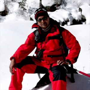
Rana Bahadur Khadka
In the world of outdoor adventure and exploration, only passionate individuals immersed in the wilderness can be travel guides in Nepal! My name is Rana Bahadur Khadka, and I am from Taplejing, Nepal. Born in 1971, I have collected 30 years of extensive knowledge in travel and tourism as a mountain guide and trip organizer. I have always been fond of exploring and navigating various gorgeous corners of the world and the challenges offered by nature.
I hope that my over two decades of honed skills in mastering the art of leading treks safely, ensuring the participant's memorable and transformative travel experience, and my vivid insight into the world of adventure, nature, and self-discovery help you bridge the gap between the pristine Himalayan grace and the human spirit as an ambassador of the wilderness.
Drop us a message
Latest Travel Guides
Our travel guides giving you travel insights, ideas, and tips across the Himalaya.