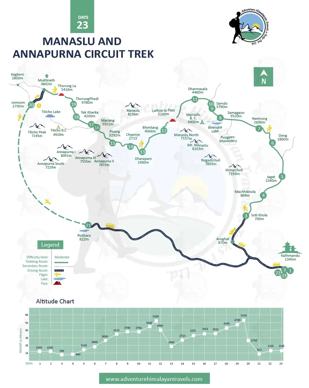
The Manaslu Circuit Trek is one of the classic Himalayan trips that encircles the eighth-highest mountain peak in the world, Mount Manaslu (8,163 m/26,781 ft), via Nepal’s longest high mountain pass, Larkya La Pass (5,160 m). Through one of the restricted areas within the Manaslu Conservation Area, it is a dream destination for true adventure seekers. Therefore, thoughtful planning, including the selection of the right trekking map, is essential.
The right Manaslu Circuit Trekking Route Map at hand helps you with more sorted logistical management, so you trek like a pro with confidence. Further, the map mentioning the Manaslu Trail distance makes it easier for you to make up your mind about potential steep ascents, descents, and longer walking hours, if any. This is your Manaslu Region Trekking Guide discussing the necessity of a map for the Manaslu Circuit Trek.
Table of Contents
What makes trekking to the Manaslu Circuit special?
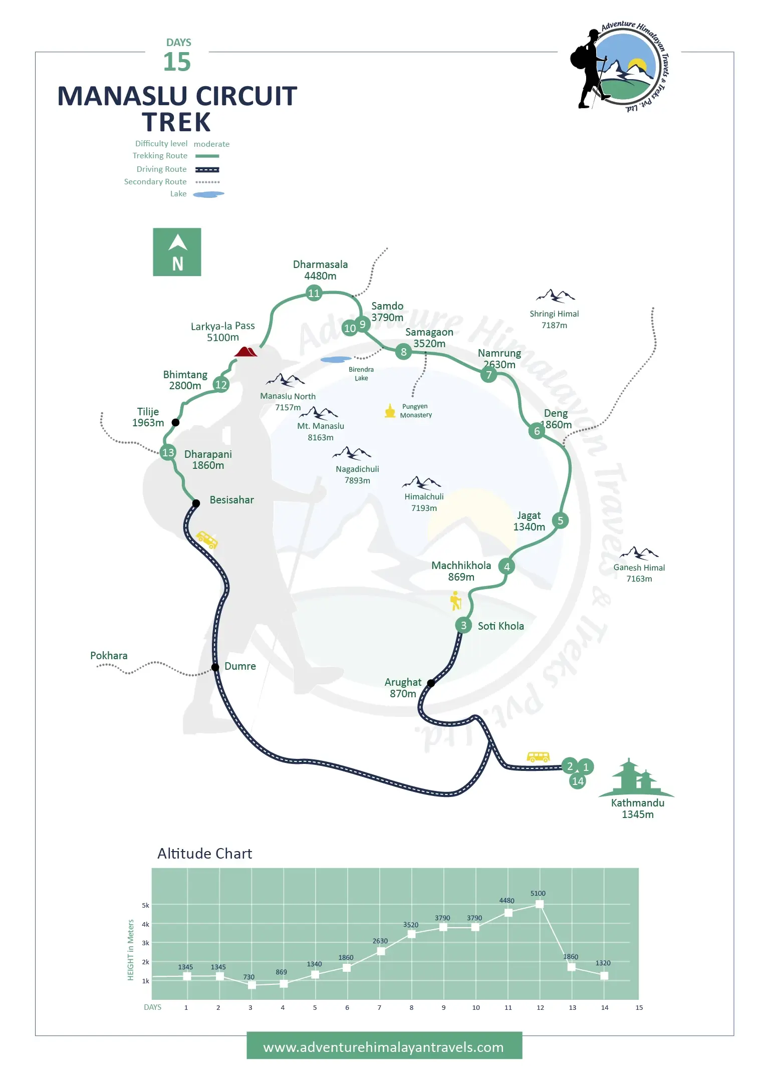
The official trek starting from Soti Khola, the Manaslu Circuit Trekking itinerary of 15 days is the standard one and takes you through the traditional villages of Maccha Khola, Jagat, Deng, Namrung, SamaGaou, Samdo, and Bhimthang via Larkya La Pass from Dharamsala. Entering the restricted land requires hiring a licensed guide, forming a group of at least two trekkers, and being accompanied by a registered local trekking agency for any adventure activities.
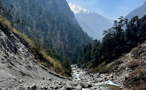
It is so that your journey is responsible while you get to relish the unspoiled blend of mind-blowing Himalayan scenery, rich Tibetan Buddhist culture, and real wilderness far from busier cousin high-altitude treks and climbs like the Everest Base Camp Trek, Annapurna Base Camp Trek, and Mera Peak Climbing. Largely untouched by modern amenities, for a smoother, pristine trekking experience, book the Manaslu Circuit Trek Map with Distance.
Manaslu Circuit Trek Map
Manaslu Circuit Trek Map and Distance Daily Breakdown
The usual Manaslu Trail distance covered is approximately 177 km/110 miles once foot walking begins on the fourth day. Starting from Soti Khola and ending at Dharapani. The reliable map for circuit trekking to Manaslu also discusses the potential side trips, as the distance covered may vary slightly based on the exact trekking trail choices, like the Nar Phu Valley Trek, the Tsum Valley Trek, or combining the Manaslu and Annapurna Circuit Trek.
In general, the typical Manaslu Circuit Trekking Itinerary can be completed in about 14 to 15 days, as recommended by professional trekking companies like Adventure Himalayan Travels and Treks. Our more than two decades of experience in organizing memorable Himalayan holidays make us your trusted partner in Nepal. So here’s the Manaslu Circuit Trek Map breakdown with daily distance, trekking hours, and elevation breakdown.
Day
Route
Approx. Trail Distance (km)
Starting altitude(m)
Ending altitude(m)
Duration
(hrs)
Major Highlights
4
Soti Khola to Maccha Khola
9km/5.59miles
710m
869m
5-6 hrs
Forested Trails
Cascading waterfalls
Suspension bridges
Hillside Gurung Villages
5
Maccha Khola to Jagat
15km/9.32miles
869m
1,340m
5-6 hrs
Entry point on the Manaslu Circuit Trek Map restricted areas
Slightly rocky terrain
Hot spring at Tatopani
6
Jagat to Deng
19km/11.80miles
1,340m
1,860m
7-8 hrs
Scenic terraced fields
Buddhist prayer flags and mani walls
Serene trail along roaring river
Close cultural ties to Tibet
7
Deng to Namrung
19km/11.80miles
1,860m
2,630m
6-7 hrs
Marks several steep uphill sections on the Map of Manaslu Circuit Trek
Excellent views of Ganesh Himal
Starting of alpine meadows
8
Namrung to Sama Gaou
17km/10.56miles
2,630m
3,520m
6-7 hrs
Stunning views of several mountain ranges
Transition from dense forests to alpine across the Shyala Plateau
Ribung Monastery and villages with Tibetan architecture
Glacial streams, wide open valleys, and the first grand view of Mount Manaslu
9
Sama Gaou to Samdo
8km/4.9miles
3,520m
3,790m
3-4 hrs
Gentle and scenic ascent to the Tibetan refugee village
Fewer villages on the Manaslu Circuit Trek Map with Distance
10
Acclimatization Day at Samdo
Side hike to Tibetan Border Viewpoint
Explore the traditional village
Visit Gompas and Mani Walls
Rest, hydrate, and prepare for the high mountain pass
11
Samdo to Dharamsala
6.5km/4 miles
3,790m
4,450m
4-5 hrs
Short but steep
Into a more remote area
Dharamsala is the only place with a larger number of houses
12
Dharamsala to Bhimthang via Larkya La Pass
23-25km (14.29-15.53 miles)
4,450m
3,700m
8-10 hours
Reaching the highest point, 5,160 m, at Larkya La Pass.
Moraines and glacial walks
Steep ascent and descent
Panoramic Himalayan views
13
Bhimthang to Tilije to Dharapani
22km/13.67miles
3,700m
1,860m
7-8 hrs
Merge into the other classic Annapurna Circuit Trek route.
Maps lead through the easy forested trails along the riverside through the improved village area.
Altitude Gain on the Manaslu Trek Map
The Manaslu Circuit Trekking journey includes hiking 3,000 m above where the level of oxygen drops significantly, 1/3 less than at sea level, and on rapid ascent without proper acclimation, anyone can encounter symptoms of acute mountain sickness (AMS). The Map of Manaslu Circuit Trek is often beneficial to visualize elevation so that your pace aligns to acclimatize well, explore the area to the fullest, and prevent potential risks.
From Soti Khola to Samagoan, the elevation gain is about 400 to 700 m daily, and from Samagoan to Larkya La Pass, it is significant, almost 1,600 m each day, while thereafter, the Manaslu trek altitude gain per day to Dharapani is a moderate loss per day. Therefore, the Manaslu Circuit Trek Map with distance is to listen to your body, rehydrate, and choose a Manaslu Circuit Trek itinerary that allows ample time for acclimatization.
Exploring Beyond the Map: Cultural and Natural Highlights
With or without the Map of Manaslu Circuit Trek, the trekking route itself reveals the hidden treasures of the region. Still, here are some of the significant cultural and natural landmarks: the deep Budhi GandakiRiver Valley and gorge, Pungen Glacier, Pungen Gompa, Manaslu Base Camp, Ribung Monastery (Lho), and villages and teahouses dotted in between, offering insights into the lives of the Tamang and Gurung communities.
A scenic transition from subtropical forests to desert-like terrain resembling the Tibetan plateaus in the rain shadow area; at certain months, you may even get to be part of unique cultural festivals. Lhosar (February-March), Dumje (June-July), Saga Dawa (May-June), Nara (typically in summer), and Cho and Yartung (Aug-Sept): pick the right season based on what you are keen on seeing.
Cultural Trek to Nar Phu Valley Trek Map in Manaslu Region
Best season for Manaslu Circuit route planning
One of the most important Manaslu route planning tips is to set off at the right time for a better experience, especially when the trail, road, and flight conditions can be greatly affected by the weather, which in high altitudes in the Nepalese Himalayas and beyond is known to be notoriously unpredictable. Even with the best Manaslu Circuit Trekking Route Map, the challenges can be there is picked wrong time for trip.
So, especially for beginners, it is advised to book your Manaslu Circuit Trek in spring and autumn. While manageable during the summer/monsoon seasons usually regarded as off time for high altitude treks and climbs after winter, for its mild temperature, best trekking trail conditions, excellent visibility, and low chances of snow and rain, the months from March to May and September to November are the best. More at The Best Time for Manaslu Trek.
The standard map for the combined trek to Manaslu and the Annapurna Circuit Trek
Practical Use of the Manaslu Route Trek Map
A high-quality map has several advantages and makes it an essential tool to navigate the rugged and challenging Manaslu Trek route in remote Nepal more efficiently. You can use the Manaslu Trek Map for clarity on setting realistic daily goals, monitoring elevation gain to maintain your walking pace, safe altitude acclimatization, locating water sources, identifying villages with major streams, and understanding the diverse terrain types.
Steep ascents and descents, landslide-prone areas, narrow cliffs, and rocky trails. It aids with emergency planning with information on the nearest exit routes, medical posts, teahouses, and villages; the map for circuit trekking to Manaslu becomes your reliable companion. Especially for first-timers who often tend to underestimate the remote challenges of the Manaslu region across valleys, high passes, and high-altitude ridges.
Top 5 tips for successful Manaslu Route Planning
Trekking alone in Manaslu is not allowed, and you must obtain at least three permits: Manaslu Restricted Area Permit (RAP), Manaslu Conservation Area Permit (MCAP), and Annapurna Conservation Area Permit (ACAP).
Carry both the physical and digital versions of the Manaslu Circuit Trekking Map, as batteries can drain quickly in cold conditions; it is better to update the offline map, as networks can be spotty in high and remote regions.
On the trek day that includes crossing a high mountain pass, start early. Mark personal notes, including timings, rest points, viewpoints, and most importantly, stay flexible while listening to your guide for local experts on weather and safe Manaslu trek altitude gain per day.
The better prepared you are, the easier the journey gets for you to tackle the Manaslu Trail distance, high altitude, and challenges of rugged landscapes; consider cardiovascular exercises and strength-building activities.
Pack for diverse climates, as the weather in high altitudes changes frequently. Layering is key, and do not forget to include waterproof and windproof gear. If you are concerned about conserving battery life at those times, use GPS only, etc.
Conclusion
The multi-day high-altitude trek to the trans-Himalayan region, the Manaslu Circuit Trekking through one of the deepest gorges in the world, Kali Gandaki Gorge, to cross the longest high mountain passes in Nepal, Larkya La Pass (5,160 m), and the Manaslu Circuit Trekking Route Map are strategic assets. It provides you with an outline of the journey with immense physical demands, equally rewarding in all terms—natural, cultural, and spiritual.
By understanding the Manaslu Trail distance, you can diligently manage the Manaslu Trek altitude gain per day, and you also get expert insight into the Manaslu route planning tips, as well as discussing the best season for Manaslu Circuit route planning. Whether you are first-time trekkers or seasoned climbers, studying the Manaslu Circuit Trek Map properly is essential to guide your pace, ensure safety, and increase your confidence.
FAQS
Can I complete the trek without a guide using the map?
No, since the Manaslu region comes under one of Nepal’s highly restricted trekking areas, trekking without a guide is not allowed. You must hire a professional and be in a group of at least two trekkers, regardless of how detailed your map is.
Why get travel insurance for the Manaslu Trek?
Although travel insurance is not a compulsory requirement like obtaining a restricted area permit, licensed guide, and registered trekking agency, for a better peace of mind, high-altitude coverage travel insurance is highly recommended.
Are side trips and routes shown in the Manaslu Circuit Trek Map?
Yes, the Manaslu Trekking Route Map usually indicates the common trails like Manaslu Base Camp, Birendra Lake, and Pungen Gompa Viewpoint, or it also stretches the Himalayan excursion to Tsum Valley and Nar Phu in the Manaslu Trekking Region.
What are the Manaslu Hike starting and ending points?
While following the standard 15 days for the Manaslu Circuit Hike Itinerary, the foot walk officially begins at Machha Khola and ends at Dharapani, but can change based on the route chosen and customizations made.
Is it okay to rely on a mobile app for the Manaslu Trek Map?
No, batteries at high altitude can drain quickly, and cold weather can affect the electronic devices adversely; therefore, we recommend you carry a printed Manaslu Circuit Trekking Route Map as a backup that you can use from the map section.
Rana Bahadur Khadka
In the world of outdoor adventure and exploration, only passionate individuals immersed in the wilderness can be travel guides in Nepal! My name is Rana Bahadur Khadka, and I am from Taplejing, Nepal. Born in 1971, I have collected 30 years of extensive knowledge in travel and tourism as a mountain guide and trip organizer. I have always been fond of exploring and navigating various gorgeous corners of the world and the challenges offered by nature.
I hope that my over two decades of honed skills in mastering the art of leading treks safely, ensuring the participant's memorable and transformative travel experience, and my vivid insight into the world of adventure, nature, and self-discovery help you bridge the gap between the pristine Himalayan grace and the human spirit as an ambassador of the wilderness.
Drop us a message
Latest Travel Guides
Our travel guides giving you travel insights, ideas, and tips across the Himalaya.

.webp)